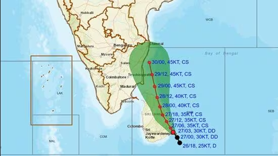
A deep depression over the southwest Bay of Bengal and the adjoining Sri Lanka coast has intensified into Cyclone Ditwah, the India Meteorological Department (IMD) said on Thursday. The weather system, which has been steadily strengthening over the past several hours, is expected to move towards the coasts of North Tamil Nadu, Puducherry and south Andhra Pradesh over the next two days.
At present, the cyclone is located 90km south-southeast of Batticaloa (Sri Lanka), 120km northeast of Hambantota (Sri Lanka), 200km south-southeast of Trincomalee, 610km south-southeast of Puducherry, and 700km south-southeast of Chennai.
The IMD had warned that the system was likely to intensify into a cyclonic storm within hours, continuing its trajectory across the southwest Bay of Bengal and the Sri Lanka coast.
The weather formation is expected to continue moving in a north-northwesterly direction, tracking along the Sri Lanka coast before emerging over the southwest Bay of Bengal. It is forecast to reach the waters off North Tamil Nadu, Puducherry, and adjoining south Andhra Pradesh by the early hours of 30 November.
Authorities have advised coastal populations to remain alert as the system intensifies and approaches the Indian coastline. Further updates and warnings are expected as the situation develops.
Meanwhile, at 10.51am, the Indian National Centre for Ocean Information Services (INCOIS) issued a tsunami alert for two areas in the Andaman and Nicobar region following a 6.3-magnitude earthquake that jolted the Sumatra coast. But at 11.17 am, the bulletin said there was no threat to the Indian coastline.
The deep depression, seen as a remnant of Cyclone ‘Senyar’ over the Strait of Malacca, moved nearly eastwards with a speed of 18kmph in the past 6 hours, and lay centred about 200km south-southwest of George Town (Malaysia), 320km east-southeast of Kuta Makmur (Indonesia), 820km southeast of Nancowry (Nicobar Islands) and 960km southeast of Car Nicobar (Nicobar Islands).


